A trip to Vietnam’s southern
Published: 24/09/2012 03:21
Ca Mau Cape on Vietnam’s southern tip was named a global biosphere reserve in 2009. It has for long been an attraction as the country’s southernmost point, but people also say they feel vulnerable here since it feels remote and cut off from the rest of Vietnam.
Source: Thanhniennews |
Provide by Vietnam Travel
A trip to Vietnam’s southern - | vietnam travel company
You can see more
- Beautiful resorts for a weekend escape close to Hanoi
- The places to come at night in Saigon
- The vestige - Gia Long waterfall
- Great landscape in Moc Chau
- An excursion on still water in Van Long
- Visiting Bo Hon Island - one of the largest in Ha Long Bay
- A short tour in Han Market
- Restored historic houses to be journey back in time for tourists
enews & updates
Sign up to receive breaking news as well as receive other site updates!
- Banh Đa Cua - a traditional Hai Phong specialty
- Exploring Lai Chau cuisine
- Hanoi ranked top 3 cuisine in the world in 2023
- Beautiful resorts for a weekend escape close to Hanoi
- Travel trends in 2023
- In the spring, Moc Chau is covered in plum blossoms.
- The Most Wonderful Destinations In Sapa
- Top 3 Special festivals in Vietnam during Tet holiday - 2023
- 5 tourist hotspots expected to see a spike in visitors during Lunar New Year 2023
- How To Make Kitchen Cleaned
-
vietnam travel
http://www.vietnamtourism.org.vn " Vietnam Tourism: Vietnam Travel Guide, Culture, Travel, Entertainment, Guide, News, and...
-
Vietnam culture, culture travel
http://travel.org.vn " Vietnam culture
-
Vietnam travel, vietnam travel news, vietnam in photos
http://www.nccorp.vn " Vietnam travel, vietnam travel news, vietnam in photos
-
Vietnam tourism
http://www.vietnamtourism.org.vn " The official online information on culture, travel, entertainment, and including facts, maps,...
-
Vietnam Travel and Tourism
http://www.vietnamtourism.org.vn/ " Vietnam Travel, Entertainment, People, Agents, Company, Vietnam Tourism information.
-
Information travel online
http://www.travellive.org "Information travel online

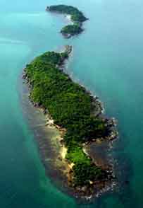 To get to the cape one can take a speedboat from Nam Can Town, which is 60 kilometers from the province’s capital, also called Ca Mau.